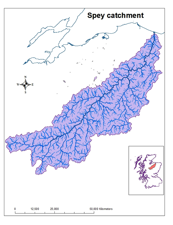
Catchment Characteristics
The River Spey is the seventh-largest river in Britain, with a catchment area of 3,000km2, and a stream network length of about 36,500km, of which the Spey mainstem comprises 170km/105miles. The River Spey emerges from Loch Spey in the Monadhliath Mountains and flows in a north-easterly direction to drain into the Moray Firth at Spey Bay. Due to the catchment configuration, most of the major tributaries join on the eastern side, draining the Cairngorm Mountains.
The largest tributary is the Avon (pronounced A’an), with a catchment size of 543km2 it forms 18% of the entire Spey catchment. The other main tributaries are the Dulnain, Feshie, Tromie, Truim, Fiddich, Nethy, Calder and Druie.
By reputation, the Spey is the “fastest flowing river in Scotland”, although this only really applies to the river downstream of Grantown. From Grantown downstream to the river mouth at Tugnet the gradient is high and uniform with a 200m drop in altitude over a river distance of 76km. From Grantown upstream to Spey Dam the gradient is much flatter with an altitude change of 58m over a river distance of 75km. Upstream of Spey Dam, the gradient increases again to the source of the Spey at Loch Spey, which lies at an altitude of 350m.
The flow of water through the catchment is monitored by SEPA, using a network of gauging stations. The lowest station at Boat O’Brig shows an average daily flow of about 65m3s-1 with a dry weather flow of about 19m3s-1. The Spey with its vast hinterland of mountain catchment often exhibits an alpine flow regime with an increase in flows in the spring due to snowmelt, although in Scotland snowfall is highly variable and this is not a consistent feature.
The human population density in the Spey catchment is generally low with a number of small planned towns housing less than 3,000 residents, e.g. Kingussie, Grantown, Aberlour and Fochabers, and, small villages of less than 500 residents, e.g. Nethybridge, Carrbridge, Craigellachie and Garmouth. In recent decades Aviemore has grown significantly and it is now the largest town in Strathspey. The catchment is split between two Local Authority administrations, the Highland and Moray Councils. The Cairngorm National Park, which was established in 2003, encompasses 63% of the catchment is within the Cairngorms National Park.
Hill farming, forestry and sporting estates dominate the land-use pattern in the upper catchment, while cattle rearing, extensive commercial forestry and arable farming become more prevalent as the valley floor widens in the lower reaches.
There are two main hydro schemes in operation in the upper catchment resulting in a significant loss of water from the Spey catchment. Scottish & Southern Energy plc diverts water from the catchments of the rivers Tromie and Truim to Loch Ericht in the Tummel/Tay catchment and Rio Tinto Alcan diverts water from the upper Spey at Spey Dam to Loch Laggan for hydro-power generation at Fort William.